Nashik's air today: where the smoke is coming from
Nashik's smoke report
The air over Nashik is almost still right now (under 3 km/h, 30 October, 08:15 IST), so smoke from the city's own sources and from nearby fires can build up instead of blowing away. 98 fires were seen within 250 km in the 24 hours to 30 October, 04:18 IST.
Ranks among the cities with pages here that have any of each: #1 has the most.
Map of the fires around the city, last 24 hours
Each dot is one fire a NASA satellite saw. The wind is calm, so there is no upwind side: smoke from fires on every side can drift in and settle over the city. Red dots are likely crop burning, brown dots other fires. Tap a dot for the village and the time.
Fires within 250 km in the last 24 hours, by direction. The wind is calm, so no side is upwind. Tap a direction to pick out its fires on the map.
What satellites see around Nashik
What satellites and surveys see around the city. Each is a different measure, so they can't be added up into shares of the air.
Fires around Nashik in the last 30 days
The busiest of the last 29 days was 27 October, with 129 fire spots within 250 km, 15 of them within 50 km.
within 250 km within 50 km
A fire spot is one fire seen on a day, however many satellites saw it (Pakistan-time days). The archive runs every day from 1 October 2026; before that it holds only the October-November seasons.
NO₂ pollution in Nashik: traffic, industry and power plants
Over the last 14 days the air over Nashik held 1.73 times the region's usual level of nitrogen dioxide (NO₂), #30 of 58 cities.
The strongest NO₂ peak within 35 km was 2.15 times the usual level, 6 km from the city centre in the built-up area of Nashik, the pattern of traffic.
From Sentinel-5P's TROPOMI instrument via NASA's GIBS tiles, which publish NO₂ as colour bands: a level here is good to about one band. NO₂ in big cities comes mostly from vehicle engines; peaks are named after what is nearby, which suggests a source but doesn't measure one. NO₂ window 15 October to 28 October 2026.
Landfills
Satellites and aircraft have measured methane rising from Nashik Municipal Dumping Ground, 9 km from the centre, 1 times, about 747 kg an hour. That puts it #22 of the 58 measured landfills in Pakistan and India.
Rank among the 58 landfill records with a measured rate in Carbon Mapper's data for Pakistan and India (this extract covers only these two countries). Rates are Carbon Mapper's automatic per-plume estimates; landfill methane also carries the smell and smoke of burning rubbish.
Power plants and industry
2 fossil-fuel power plants and 208 industrial areas lie within 50 km of Nashik. The largest, RattanIndia Nashik Thermal Power Project, can generate 1,350 MW.
1 always-hot site that NASA's satellites saw burning on 20 or more days in 2025: Vilholi (48)
Within 50 km of the city centre, on either side of the border. These are lists of what is there, not measures of how much each adds to the air.
Every mapped source within 50 km of Nashik
Tap a layer to hide it, or a site for its name.
Brick-kiln surveys, OpenStreetMap, Carbon Mapper and NASA FIRMS, on either side of the border. These map what is there, not how much each adds to the air. /sites/ · Site lists built 26 October 2026.
Fires around Nashik this season compared with past years
Fire spots within 250 km of Nashik from 1 October to 29 October, each year. These count Suomi NPP alone, so every year is measured by the same instrument and the years compare fairly (the 30-day chart above counts all five satellites, three VIIRS and two MODIS, so its numbers are higher).
* 2026: 1 day without Suomi NPP data: a floor
Nashik against the other cities
Each strip holds the cities with pages here that have any of it, the most on the left; the red mark is Nashik. They are different measures, so a high rank on one isn't a larger share of the air than a high rank on another.
All the rankings: city rankings
Send this to someone in Nashik
Pasted into WhatsApp or X, the link shows this map of the fires and the wind, redrawn every few hours.
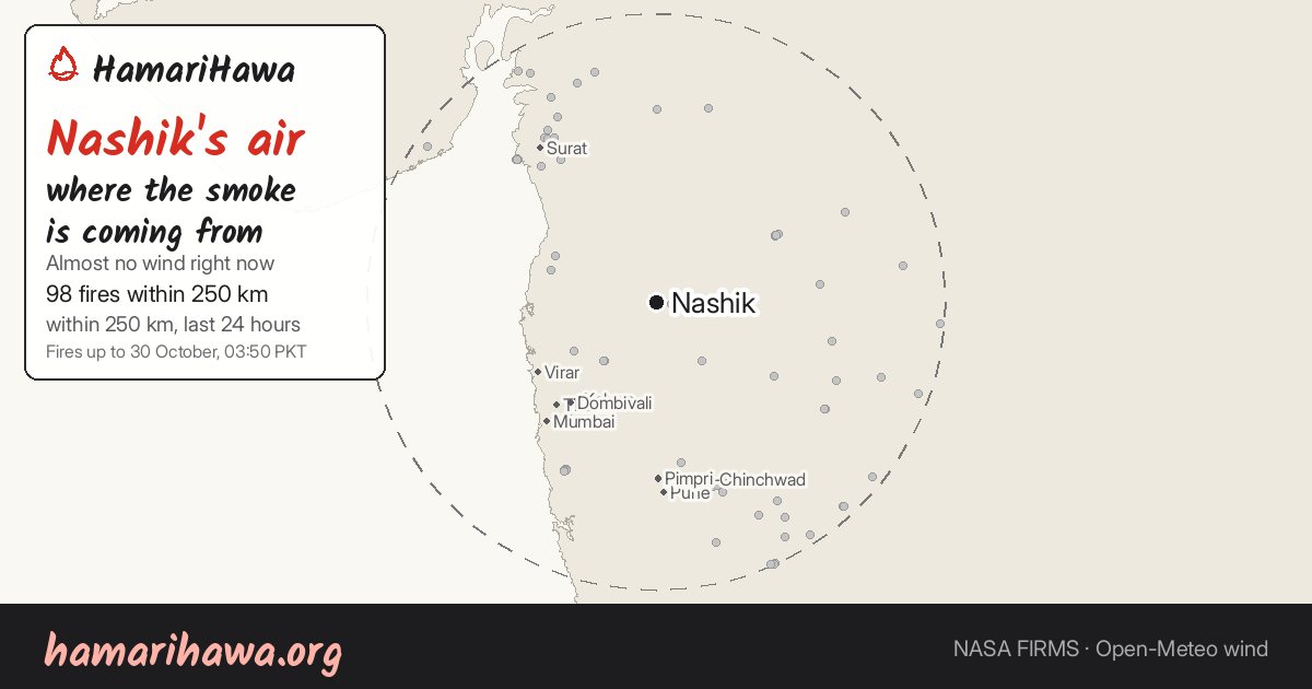
Nashik air today: where the smoke is coming from
hamarihawa.org
All the numbers
Every table behind this page.
Fires within 250 km by direction, last 24 hours
| From the | Fires |
|---|---|
| north | 4 |
| north-east | 6 |
| east | 8 |
| south-east | 17 |
| south | 17 |
| south-west | 16 |
| west | 1 |
| north-west | 29 |
Fires within 250 km in the last 7 days
| District | Province or state | Country | Distance | Fires | On farmland |
|---|---|---|---|---|---|
| Surat | Gujarat | India | 171 km | 136 | 16% |
| Ahmadnagar | Maharashtra | India | 133 km | 100 | 88% |
| Pune Division | Maharashtra | India | 174 km | 86 | 81% |
| Raigarh | Maharashtra | India | 165 km | 70 | 1% |
| Jalgaon | Maharashtra | India | 182 km | 37 | 81% |
| Jalna | Maharashtra | India | 218 km | 37 | 89% |
| Satara Division | Maharashtra | India | 237 km | 34 | 41% |
| Bid | Maharashtra | India | 214 km | 30 | 97% |
| Thane | Maharashtra | India | 120 km | 28 | 4% |
| Aurangabad | Maharashtra | India | 167 km | 25 | 84% |
Fires around Nashik this season compared with past years
| Season | Fire spots |
|---|---|
| 2019 | 231 |
| 2020 | 348 |
| 2021 | 548 |
| 2022 | 340 |
| 2023 | 422 |
| 2024 | 331 |
| 2025 | 434 |
| 2026 (so far) | 634 (1 day without Suomi NPP data: a floor) |
Landfill methane records
| Site | Methane | Plumes seen | Last seen | Rank |
|---|---|---|---|---|
| Nashik Municipal Dumping Ground (Nashik Division, India, 9 km) | 747 kg/h | 1 | 11 January 2026 | 22 of 58 |
Rank among the 58 landfill records with a measured rate in Carbon Mapper's data for Pakistan and India (this extract covers only these two countries). Rates are Carbon Mapper's automatic per-plume estimates; landfill methane also carries the smell and smoke of burning rubbish.
Every measure and rank
Where Nashik stands among the 58 cities with pages here, on each measure. They are different measures, so a high rank on one isn't a larger share of the air than a high rank on another.
| Measure | Nashik | Rank |
|---|---|---|
| Fire spots within 250 km, last 30 days | 1,724 | 35 of 58 |
| NO₂, times the usual level (14 days) | 1.73× | 30 of 58 |
| Landfill methane within 50 km | 747 kg/h | 23 of 34 |
| Measured plant CO₂ within 50 km | none measured | – |
| Brick kilns within 50 km | – | – |
| Industrial areas within 50 km | 208 | 18 of 58 |
| Always-hot sites within 50 km | 1 | 13 of 23 |
Ranks on today's fires
Nashik's place among the cities, on the numbers that change with each satellite pass.
- Fire spots upwind, last 24 hours: calm wind, no upwind direction
- Fire spots within 250 km, last 24 hours: 19 of 57
- Fire spots within 250 km, last 7 days: 35 of 58
All the rankings: city rankings
Questions about Nashik's air
Where is Nashik's smoke coming from today?
The air over Nashik is almost still right now (under 3 km/h, 30 October, 08:15 IST), so smoke from the city's own sources and from nearby fires can build up instead of blowing away. 98 fires were seen within 250 km in the 24 hours to 30 October, 04:18 IST.
Are crop fires burning near Nashik?
In the last 24 hours NASA's satellites saw 98 fire spots within 250 km of Nashik, and 1,724 in the last 30 days. Satellites only see what is burning as they pass, and not under cloud.
How bad is traffic pollution in Nashik?
Over the 14 days 15 October to 28 October 2026, nitrogen dioxide in the air over Nashik (within 15 km) was about 1.73 times the usual level of the surrounding region, roughly 3.22 ×10¹⁵ molecules/cm². Of the 58 cities with enough clear days, it ranks 30.
Which landfills near Nashik release methane?
Carbon Mapper has measured methane plumes from Nashik Municipal Dumping Ground (747 kg/h).
Every number on this page is also in machine-readable form (JSON).
More about Nashik
- Nashik on the live map
- Fires in Nashik Division district, every season since 2019
- Daily fire pages
- Fire trends
- All cities
Nearby cities: Mumbai (140 km), Surat (164 km), Pune (164 km), Vadodara (264 km)
Fires up to 30 October, 04:18 IST. This page updates every 15 minutes. Upwind is a guide, not proof: smoke can travel further than 250 km, the wind turns during the day, and satellites can't see fires under cloud. A fire spot is one fire, about 375 m across, however many satellites saw it. Fires: NASA FIRMS (VIIRS and MODIS). Wind: Open-Meteo's weather model. Air: Copernicus CAMS model estimates, which read low in winter.